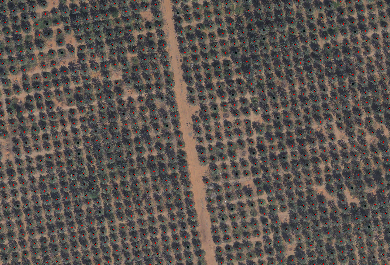
In line with the UAE’s efforts to increase agricultural productivity, the Mohammed Bin Rashid Space Centre (MBRSC) developed AI technology that helped detect 45,000 palm trees, in various regions of Al Ain. The project is within the framework of UAE’s approach to enhance cooperation between government entities to improve services and develop innovative solutions that are both cost and time saving.
MBRSC developed the AI technology to analyse the 10 centimetre-per-pixel resolution images provided by Al Ain Municipality by utilising in-house technology and experts from the Centre’s Application Development & Analysis Section. Through the AI system, MBRSC was able to detect 45,000 trees in less than a week, with an accuracy of 98.7%. With this technology, MBRSC was able to provide a solution to achieve an acceptable degree of accuracy to identify and extract very small objects using remote sensing technology, which would otherwise have taken months of work to achieve.
The project demonstrates the readiness and ability of Emirati competencies to employ remote sensing and artificial intelligence technologies to obtain innovative solutions that help the country achieve more with lesser time, money, and effort. It further reflects the spirit of cooperation between government agencies in the country and reinforces the principle of cooperation among them to improve service offerings in the UAE. The collaboration is also an example of how modern technology can assist in realising the UAE’s national agenda of ensuring sustainable development while preserving the environment and achieving a perfect balance between economic and social development.
Unique services
Saeed AlMansoori, Head of Application Development & Analysis Section, MBRSC, said: “Our strategy of combining the use of our high-resolution remote sensing capabilities with an evolving AI-driven analytics and delivery platform ensures that we offer some of the best services for environment monitoring and detection in the region with great accuracy.”
He added: “The delivery of AI technology for analysis and image processing for this project demonstrates our ability to leverage requests via next generation analytics architecture to deliver insights quickly and accurately. These services provided by MBRSC have been used for monitoring environmental changes, in addition to disaster relief efforts as artificial intelligence enables us to integrate information, analyse data, and use the resulting insights to improve decisionmaking.”
In addition to helping UAE government entities with their projects and initiatives, MBRSC is also part of the International Disaster Charter and Sentinel Asia, playing a crucial role in disaster relief and management globally. Furthermore, the Centre’s geo analytics platform has contributed to providing potential solutions in terms of large area coverage, spatial and spectral information for government and private entities.